
Geology
draft letter to County Geologist
This risk map suggests that in terms of geology, Los Gatos Canyon is not a particularly good place to build a house, inspite of the untold thousands already there. However, the center-left portion of the circled 5 square mile area near the Patchen historical monument, at Mt Charlie Road and Old Santa Cruz, looks safer than most.
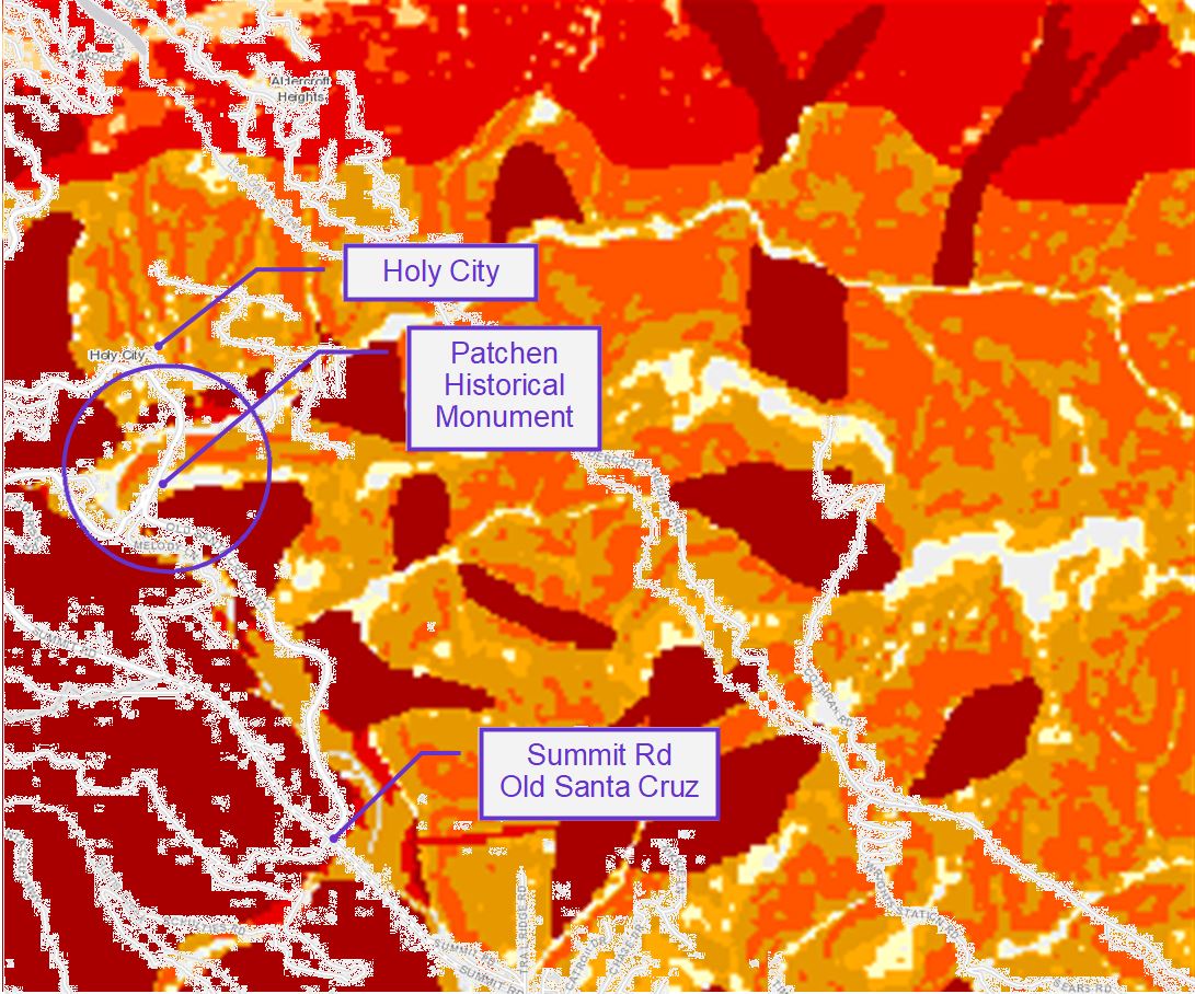 Narrowing it down to the half-dozen acres just north of that intersection shows that particular area to be comparatively stable – slide map on the right with APN outlines notwithstanding.
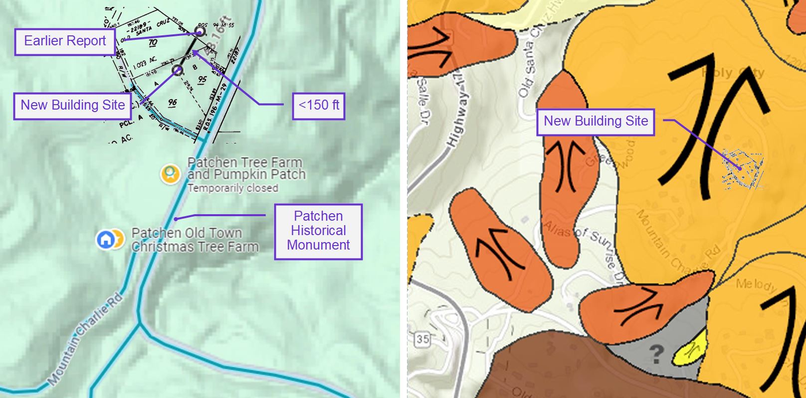
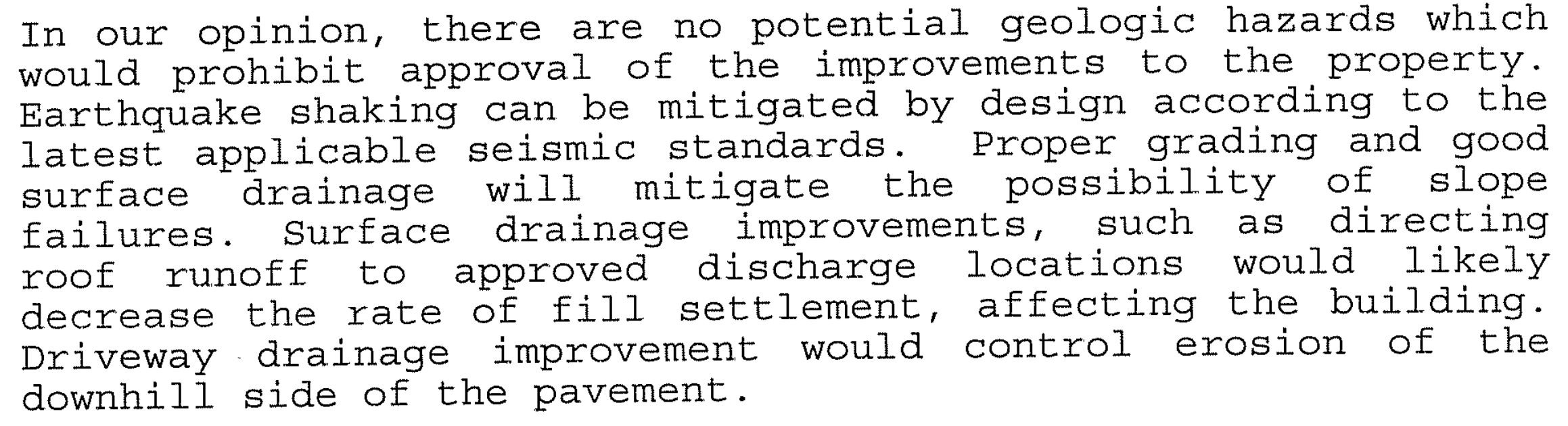
We are seeking Building Site Approval for a site less than 150 feet from the site of a 1998 geology report by Buckley Engineering that shows “no potential geologic hazards which would prohibit approval.”
My question is the probability that our property, in such close proximity to the other one, can become problematic 25 years later, in the absence of significant geological activity in the interim. Of course, we lack your expertise, but I want to ask you to please take a second look and share your thoughts on the subject.
When I spoke to Jim Baker about it some years ago, he seemed to indicate that the 1998 report could satisfy the County requirement and avoid the expense of an additional investigation. Years have passed, Jim has retired, and we realize that there are limits to what you are able to do, but we would greatly appreciate any assistance you can offer before we commit to the cost of a new report.
![]()
See the Powers report at;
https://www.dropbox.com/scl/fi/e0jl348rhud44jzsrrgsb/PowersGeosciences.pdf?rlkey=zhfatvh63rklxx7yyjjandhta&st=94j6bpm2&dl=0
My comments in green;
1.0 “Significant grading/modification of the natural ground surface has been completed and accompanied these land uses throughout the Site’s history.”
No evidence of this in the report.
4.1.3 “Site topography has been significantly modified via grading, most likely associated with current and historic agricultural land uses (The Site used to be a fruit orchard and is currently operating as a Christmas tree farm).”
No evidence of this in the report.
4.1.3 “It does appear much of the parcel has been graded to some degree so natural slope gradients have most likely been modified/scraped to some degree. Based on an analysis of historical aerial photographs, the general area was possibly graded to accommodate agricultural land use, however it does appear the site was always moderately to gently sloped.”
There is no evidence in the report that “much of the parcel has been graded”. If there are “historical aerial photographs” to this effect, we would like to review them. My examination of historical photographs does not suggest that “the general area was possibly graded to accommodate agricultural land use”. On the contrary, grading for that purpose was never common in this area.
4.1.3 “It is likely that some small-scale regrading/scarping took place during the transition from a fruit orchard to a Christmas tree farm.”
Not likely because neither orchards nor Christmas tree farming involves regrading/scarping of any kind.
5.0 GEOLOGIC HAZARDS
5.1 Unrelated textbook quotations
5.2 Unrelated textbook quotations
5.3 Unrelated textbook quotations
5.4 An emergency family plan should be prepared14, 2025
Irrelevant at best
5.5 “In our opinion, provided that our recommendations (and those of the project geotechnical engineer are followed), we believe that these features do not pose an unacceptable risk to proposed development and therefore, we consider the hazard due to co-seismic deformation under and adjacent to the proposed development areas to be ordinary for a standard design lifetime (50 years). ”
5.6 “Based on the results of our investigation and provided our recommendations (and those of the project geotechnical engineer) are adhered to, we consider the hazard posed by landsliding at the Site to be ordinary for a standard building design lifetime (50-years).”
5.7 “Consequently, provided our recommendations and those of the project geotechnical engineer are followed, we consider the hazard posed by ground surface rupture due to faulting at the Site to be ordinary to ordinary for a standard building design life-time (50-years). ”
6.0 “Provided all our recommendations (and those of the project geotechnical/civil engineer) are followed, we consider the risk posed by these geologic hazards to be ordinary for a standard design lifetime of 50-years and that the building envelopes shown on Plates 1, 2 and 3 are suitable (geologically feasible) for residential development/habitable structures.”
6.0 “based on the results of our investigation and provided that our recommendations (and those of the project geotechnical engineer) are adhered to, we consider the above discussed geologic hazards to be ordinary for a standard building design life-time (50 years). ”
7.0.3 “We recommend that the artificial fill mapped under the building envelopes be removed and replaced as engineered fill to withstand settlement/differential movement of this material in accordance with recommendations provided by the project geotechnical engineer.”
The actionable words here are “artificial fill”. The amount is extremely small, as can be witnessed by a geologist at the time the work is done. Furthermore, not having seen the engineering drawings of the proposed pad location, it has long been understood that a retaining wall would likely be required in any case, so no additional work would be required to correct any artificial fill other than that required for backfilling behind the retaining wall.
![]()
I have read your report and I have a couple of questions if you don’t mind.
I think we all know that the Santa Cruz Mountain area is a really bad place to build houses, but there are lots of them here and lots more on the way. Understanding that, we would like to avoid needlessly aggravating that reality in the minds of the County folks. So any references to that which you could leave out and still protect yourself legally would be appreciated.
In paragraph 2.0 you reference aerial photographs, which are not included in the report. We would like to review those with you and compare with those that we have gathered.
This might not seem necessary, but a slight change in the wording in the fifth bullet of paragraph 2.0 could avoid the subtle misunderstanding in some impressionable minds that those things occurred in 2025.
“trenches/test pits completed in February of 2025 to evaluate the hazard posed by ground surface rupture due to faulting, co-seismic ground deformation, and landsliding.”
in place of
“trenches/test pits to evaluate the hazard posed by ground surface rupture due to faulting, co-seismic ground deformation, and landsliding completed in February of 2025.”
At the end of paragraph 3.0, there is a reference to the 7.1 1989 quake. It might be worth noting that, in spite of the proximity of the fault, houses within a half-mile radius of the site, including mine, suffered little to no damage.
Paragraph 4.1 states that, “Site topography has been significantly modified via grading, most likely associated with current and historic agricultural land uses”. Having an extensive background in agriculture, I can confidently say that, aside from what is mostly irrigated land farming in the surrounding valleys, it is not a common practice of grading in the production of perennial crops in this area, the one exception being wine grapes, and this land was never used for that purpose.
Also paragraph 4.1 states, “Site topography has been significantly modified via grading, most likely associated with current and historic agricultural land uses”. We would very much like to review whatever evidence that might lead to such a conclusion.
The last paragraph o 4.1 says, ” It is likely that some small-scale regrading/scarping took place during the transition from a fruit orchard to a Christmas tree farm.” There was no regrading or scarping and there was no transition from orchard to tree farm. The 1968 aerial photo shows fewer than a dozen trees, none of which were remaining from the prior orchard.
Section 7.0, paragraph 4 is based on speculation and is an issue for the geotech engineer, and should not be included in geology
1-1-31; Santa Clara County flight line C_1436, frame 8; black and white; nominal scale 1:18,000.
8-1-39; Santa Clara County flight line CIV 1939-F, frames 286-90 and 286-91; black and white; nominal scale 1: 20,000.
4-25-1948; U.S. Forest Service flight line CDF 5-3, frames 4-50 and 4-51; black and white; nominal scale 1: 10,000.
4-1-50; Santa Clara County flight line CIV 1950, frames 17G-105, 17G-106, and 17G-107; black and white; nominal scale 1: 20,000.
6-9-1956 and 6-2-1956; U.S. Department of Agriculture, flight line CIV-1956 frames 6R-55 and 2R-72; black and white, nominal scale 1: 20,000.
7-16-63; flight line SCL, frame 2-114; black and white, nominal scale 1: 20,000
5-16-65; flight line SCL, frame 11-117; black and white, nominal scale 1: 20,000
10-29-1980; Santa Clara County, GS VEZR, frame 2-172; black and white; nominal scale 1:24,000.
8-19-85; Santa Clara County flight line Lexington Reservoir Drainage Flight 1985-C, frames 3-13, 3-14, and 3-15; black and white; nominal scale 1: 12,000.
University of California, Santa Cruz, University Library, Aerial Photograph Collection (online) https://digitalcollections.library.ucsc.edu
University of California, Santa Barbara, Library, Aerial Photograph Information (online) https://mil.library.ucsb.edu