
~Historical Grading
Parcel 558-08-095, Parcel B (now part of APN 558-08-141), has undergone grade changes during two distinct time periods in its history. The two periods are described as Stage 1 (prior to the late 1940s) and Stage 2 (since 1976). It is impossible to determine exact details relating to these changes, but the following is a summary of what is known of the most recent history.
Stage 1 (prior to the late 1940s)
Below are aerial photos provided by the County, attempting to show the subject area as it has evolved since 1956. The images appear to be from multiple sources, including Google Earth, Historic Aerials, and others. It is unclear whether all are true orthographic images, and they are not particularly useful in their current form, but expanding and cropping them to the same scale makes them adequate for our purpose.
After cropping, labeling, and scaling the six images and overlaying a parcel map, we can view them accurately from the same perspective below.
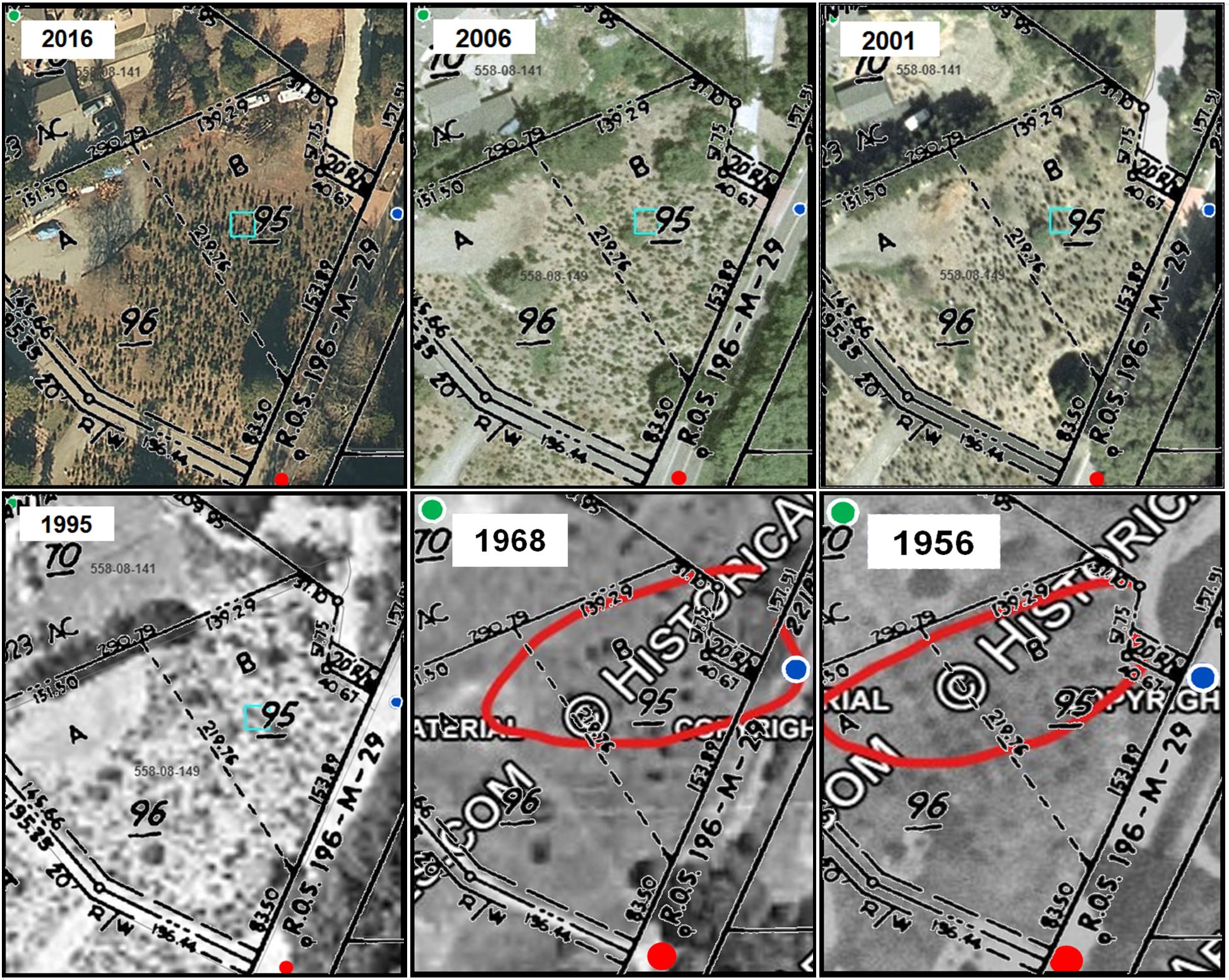 Having personally planted Christmas trees in that area, beginning at the time I purchased the property in 1976, I can attest that the area in question was flat and in the same condition as it exists today, less some minor grading after 1976.
- The 1995 photo also shows that to be the case with the two large Oaks, separated from the area to the north by a steep slope, then more Christmas trees in the flat area.
- The 1968 photo does not offer any definitive information.
- The 1956 image shows the entire area as a Bartlett Pear orchard, with trees planted in a regular pattern, but with the subject area excluded, suggesting that the flat area with a sharp drop on the south side existed at that time and was not suitable for planting.
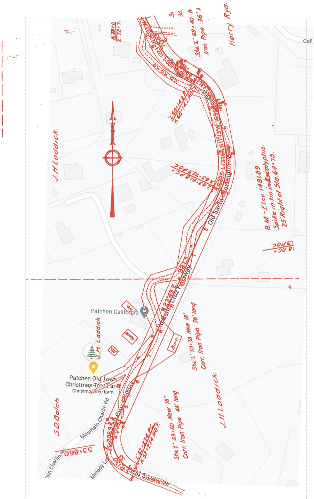
The image below, composed of a current Google map overlayed with an engineering drawing of the widening and paving of Old Santa Cruz in the 1920s, shows very distinctly that the original road, constructed in the 1850s, ran next to the subject area on the east side, immediately below it on the steep slope. The original roadway was dug into that steep bank to avoid an even steeper area to the east. The inescapable conclusion is that the excavation resulted in a slide during the next heavy storm, creating the flat area in question.
click here
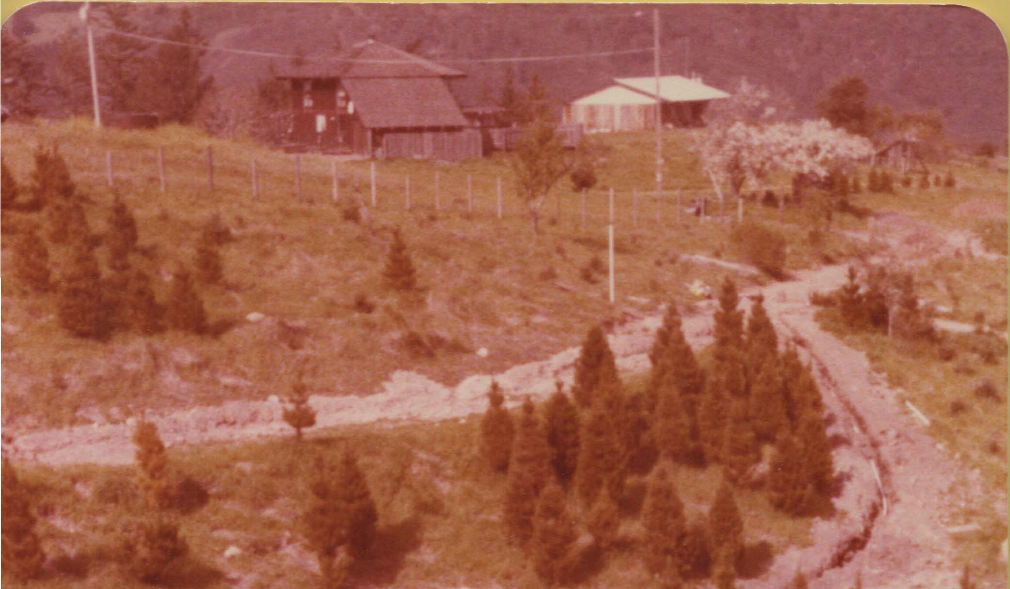
The next image, taken by me in the 1970s, shows a PG&E pole with a transformer and a visible secondary connection. It also shows a structure in that area, indicating that development had occurred prior to that time. The structure has since been removed, but having personally been inside that building, I recall it having a bunk bed built into one wall and a metal roof. I don’t know if there was water connected, but there was a steel water tank located nearby, under the flowering pear tree in this photo. The Ryan Water Company pipeline ran within 200 ft of this building, suggesting that it was most likely connected.
A recent first-hand update from a man who grew up across the road from the location in the 1940s reveals that the building was the cabin where Claud Castor would camp out from time to time[i]presumably when things were not going well at home, which was later converted to a chicken coop. The website of the Patchen California Christmas tree farm, which originated in 1969, makes a similar reference to that structure.
- The pear orchard dates back to before the turn of the Century, with dried fruit from it having been displayed at the American Exposition and World Fair in New Orleans in 1885.
– Several of the pear trees are still bearing fruit today, with one located on the slope just north of the flat area. - Photographic evidence proves the existence of a structure in that area prior to the 1970s.
One living witness attests to a “living space” structure having existed there in the 1970s.
– A second witness recalls a person living in the structure in the 1940s. - In the absence of any evidence to the contrary, there is no reason to believe that the flat area is anything other than a naturally occurring slide or the result of very early development, most likely the road construction in the 1850s.
To quantify the extent of this natural slide, an analysis was conducted to quantify the volume of dislocated soil, details of which can be seen here.
The summary cut/fill composite image shows;
- The gray/black lines are from the topo survey, recorded in 2016.
- The red shaded area reveals elevation points within the remaining undisturbed soil area adjacent to the affected area.
- The green, dashed lines are extrapolated from the topo survey contours in conjunction with the adjacent undisturbed soil area and the surrounding terrain.
- The blue represents examples of how the cut and fill volumes are defined.
Next is the cut/fill composite overlayed with the proposed ADU outline is shown here.
As can be seen, the 317 contour line is the lowest elevation inside the ADU footprint and there is no fill within that envelope. The highest natural line experiencing any fill is line 311, which is also will outside the footprint.
Stage 2 (since 1976)

By: Jim
Written: June 16, 2024
Published: June 16, 2024
Revised: July 5, 2024
Revised: June 28, 2025
Revised: September 5, 2025 – 1850s road construction
footnotes
| ↑i | presumably when things were not going well at home |
|---|